
So why do Laysan Albatross fly so fast? Newton's third law of motion tells us that for horizontal flight, the lift on a birds wing must equal the weight of bird. The lift is proportional to the bird's velocity squared times the area of its wing. Thus, the greater a bird’s weight, the faster a bird must move through the air to have sufficient lift to allow horizontal flight. For the large Laysan Albatross this cruising speed works out to 36 mph relative to the air!


Enhanced Trade Winds
The Honolulu Airport is reporting winds blowing 15 to 25 mph with higher gusts today, December 26th 2016. These winds are the result of an enhanced pressure gradient, a change in pressure over a distance, between a strong surface high-pressure area to our north and lower pressure nearer the equator in the Intertropical Convergence Zone or ITCZ (area of white clouds at the bottom of the figure below). The image below shows infrared satellite image overlaid with sea-level pressure contours in green for 8 AM this morning. Winds barbs are also plotted in white with the feathers indicating the wind speed and the staff indicating the wind direction, from the northeast. Strong trade winds are forecast to continue through the week this week.

Return winds aloft are bringing high clouds (yellow and red colors) over Hawaii from the southwest as seen in the colored IR image below. High winds from the southwest and low level winds from the northeast is a hallmark of the Hadley circulation that dominates our weather over the Hawaiian Islands. I will expand on the science behind the Hadley circulation in a future blog.


Return winds aloft are bringing high clouds (yellow and red colors) over Hawaii from the southwest as seen in the colored IR image below. High winds from the southwest and low level winds from the northeast is a hallmark of the Hadley circulation that dominates our weather over the Hawaiian Islands. I will expand on the science behind the Hadley circulation in a future blog.

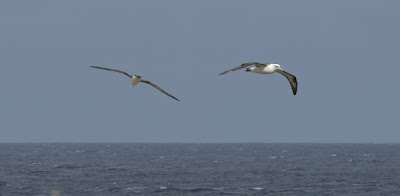
Dynamic Soaring
Back to the Laysan Albatross. The Laysan albatross glides just above the waves for long distances without flapping its wings. How does it do this? In 1883, Lord Rayleigh first suggested that a bird could continuously soar in nearly-circular flight on an inclined plane that crosses a thin wind–shear layer. He correctly observed that the birds extract energy from the increase in wind speed with height near the surface of the ocean, aka the "wind-shear layer" (see figure below). In a trick called "dynamic soaring" the albatross turns into the wind to gain height while losing air speed (~30 mph) and turns away from the wind and dives to gain air speed (~60 mph). This is akin to a bicycle rider gaining speed while coasting down a steep hill and losing speed cycling uphill (converting kinetic energy into gravitational potential energy). However, the bird gains elevation fast, like taking an elevator, just by turning into the wind shear without having to do work, smart bird!
Kaena Point
Finally, why is Kaena Point such an ideal place for an Albatross colony? Kaena Point is the westernmost tip of land on the island of Oʻahu.
In 2011, the United States' first predator proof fence was constructed at Ka’ena Point, costing ~ $290,000.[6] The fence is approximately 2,133 feet long, and encompasses 59 acres of land.[7] The total population of Laysan Albatross fledglings, Wedge-tailed Shearwater fledglings, Ohia, Sandalwood trees, and several other species have risen significantly since the fence was installed.[8]

Aside from the protected habitat, much of the point is comprised of sand dunes that form a low hill that is easy for the wind to traverse, yet to the east the Waianae mountain range forms a formidable barrier to the wind. In the photo below you can see the west end of the Waianae mountains and if you look close you may be able to spot the fence running along the bottom. As a result of the orography, or terrain, the wind accelerates across Kaena Point like a wind tunnel.

And so the Laysan Albatross happily soars into the sky on fresh trade winds accelerated by Oahu's steep orography.


